 Live Music Archive
 Librivox Free Audio
 Metropolitan Museum
 Cleveland Museum of Art
 Internet Arcade
 Console Living Room
 Books to Borrow
 Open Library
 TV News
 Understanding 9/11
tv Hannity FOX News September 3, 2010 12:00am-1:00am EDT
12:00 am

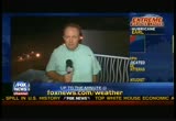
always looking -- ops here because we are always looking out for you. >> >> shepard: i'm shepard smith in new york this is fox news continuing coverage of hurricane earl. as the storm m the stormt moves closer to the united states. the national hurricane center reports earl is a strong category two hurricane, winds us0 miles-an-hour. it is fewer than 160 miles from cape hatteras, north carolina. the storm is expected to pass near the outer banks within the next few hours packing hurricane force winds that extend 70 miles from the storm's center. nasa has been using photographs for the last four days. you can see how the storm has been growing and rolling closer to the coast and closer to north carolina. the first strong bands of rain have already started to hit outer banks of north carolina.
12:01 am

it is hit and miss you know how those bands go. today police went door-to-door to make sure everybody had received evacuation notices because the state's governor warned once the storm hits folks who decided to stay are pretty much on their own. we have extensive team fox coverage throughout the night. rick leventhal on the east end of long island in montauk. monitoring the storm, first jonathan serrie in north carolina. i'm told the winds are come and go? >> reporter: they are indeed. the winds are picking up and continue to pick up at a slow, but stable pace. you said it was hit and miss as far as the rain that is so true. the radar shows the rains moving into some of the outer banks here where we are in kill devil hills, we've only experienced a few sprinkles. let me show what is happening here with the surf. we've been experiencing powerful surf all day that continues to build.
12:02 am

that's a major concern along the beautiful beaches of the outer banks, one of the major draw us of tourists from around the country as well as other countries. a big concern is beach erosion. what is the heavy wind and pounding surf going to do to the beaches of the outer banks, even if hurricane earl doesn't score a direct hit on these barrier island communities? >> shepard: what have the locals been saying about evacuation and whether people have been evacuating? >> reporter: you know, it depends on how remote the area is. when you go to hatteras island one of the more remote sections, there's a mandatory evacuation not only for visitors, also local residents. if you move to a more accessible area like the one i'm in at kill devil hills, there's a mandatory evacuation, it only applies for visitors. it only applies to nonresidents. it is operational for residents. what we are finding is by and large people are heeding the
12:03 am
evacuations. earlier in the day they packed up and got off the island in places where operational, we are finding the -- optional, we are finding the vast majority of residents want to hunker down, keep an eye on their property. they seem to be playing it safe not wanting to take chances. they are taking precautions even though many residents are staying on the island. >> shepard: the worst of it is supposed to be this the middle of the night between midnight and 3 a.m.. i don't know about you, it has been my experience over the years that the scariest hurricanes are the ones you can't see in the middle of the night so many sounds, it is frightening. >> reporter: absolutely frightening. you can be in this big building because of the pressure differences, you will have doors slamming. then the power goes out. it gets spooky. we don't know if that is going to happen with this system. so far we have power. i can tell you, being through many overnight hurricanes, it
12:04 am
can be absolutely terrifying. the other thing is, there are more unknowns. once the power goes out in the middle of the night you can't inspect the damage until after sunrise rise. >> shepard: flashlights, candles are out, history says there might be a few hurricane parties tonight? >> reporter: absolutely, we've seen a few already. >> shepard: tell us about those, that sounds the most interesting to me. >> reporter: a lot of young people have been going to the beach wanting to look at the waves, inspect what is going on at this point. most people seem to be hunkered down in their homes. whatever hurricane parties are going on are mostly going on behind closed doors. >> shepard: didn't get an invitation. jonathan serrie in north carolina where it is supposed to be bad between midnight and three. stay safe. hurricane earl expected to pick up speed. you look on the right of the screen, storm is moving at about 18 miles-an-hour, which is faster than it had been moving.
12:05 am
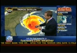
the winds have come down over the past 24 hours. it was category 4 at one point, category 3 yesterday and much of today. this evening down to category 2, just like our chief meteorologist predicted it would. what else do we know? >> it did get back to category 412 hours ago, winds 140 miles an hour. scary when you have a cat 4 storm on your shore and it weakens, that is good news. we've been saying it is going to take this right hand turn. how closely it does to the shore makes a big difference. i think we are in pretty good shape. there are going to be problems from the storm nonetheless. you get a good idea, the radar come out 260 miles from the ground, from where it is located. satellite imams come from above. radar comes from the ground. radar come out 260 miles. you can get in and see the center of the storm and those last few images you see it pulls east takes that right
12:06 am
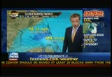
turn we expected. we've got the rain pulling onshore right out in winds are not that bad with. the latest numbers as far as winds go, keep in mind right here in the center, we still have 110 mile hour winds. 140 miles in, winds at around 15 to 10 miles an hour just a little inland. the darker blue that is 30 mile hour winds across areas of the southern cape. 17 cape hatteras, farther north into that 20 range. it is going to get worse. winds are coming out of the north that is going to cause the bay to over flow from the sound. here's what we've been talking about what we look at when we see the atmospheric conditions this is how much moisture is in the atmosphere high up around 10 to 15,000 feet in the atmosphere. you see, you know it has been hot across the northeast temps into the 90s breaking all kinds of records. this is a big ridge of high
12:07 am
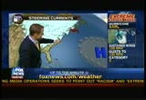
pressure that has been here stopping the storm a political from full -- from pulling north. that's the trough we've been expecting to make a big difference. here's the storm now high pressure steering the storm towards the northwest, cat 4 moving towards the northwest. finally it takes that right hand turn just around this periphery of high pressure. we start to feel the affects from this front coming in this big trough that is a fall-like trough that's going to come in tonight now that we've made that turn it is going to begin to move this thing and barrel around 25 to 30 miles-an-hour, is going to be the forward progression by tomorrow. behind this it is going to feel like fall, which is going to be a welcome for a lot of people across the northeast after this heat. winds, hurricane force winds anywhere that red, yellow tropical storm force winds tonight around cape hatteras. tomorrow it begins to book. by around 10:00 at night,
12:08 am
nantucket beginning to see hurricane force winds, i think. it is going to be a quick mover around two to three hours of maybe hurricane force winds here during the overnight hours tomorrow night. then it moves out and we are going to be looking good for your saturday, sunday, labor day. those plans you have across the eastern seaboard, the beaches are going to look spectacular. >> shepard: i want to go through different sections. i want to tart with delmarva, delaware, maryland, jury sreurpb. what are you going to feel at -- virginia. what are you going to feel? >> waves are going to be nuts going to be that big soap bowl of things going crazy. -- soup bowl of things going crazy. winds 20 to 30 feet, jersey shoreline tomorrow is a rough one. saturday maybe saturday morning stay out by saturday afternoon, the riptides should subside. >> shepard: what about jersey, new york and connecticut as you move up the shore? >> a little bit of the storm
12:09 am

surge maybe three to five feet, maybe around eastern areas of long island around parts of the cape you will have that. farther east you go is where you are going to see rain. some areas maybe three, four inches of rain. just hugging coast. it is a really sharp gradient between the areas that are really impacted from the storm and the areas that don't get much of anything. new york city a few 20 mile hour winds, maybe a shower or two. long island 100 miles, three, four inches of rain and winds maybe 60 miles-an-hour. >> shepard: massachusetts, maine, nova? >> yeah, well nova scotia that's a big one it is going to be a weakening storm but a rapidly moving storm, potentially some hurricane force wind there is. if anybody gets a storm surge from this, still going to be the right it is going to be nova scotia. maine probably get significant rain out of it and winds.
12:10 am
the worst of it as far as storm surge that's going to be our friends up in canada. >> shepard: rick, thanks very much. i was hoping to read that, too late now. we have a lot ahead in in hour. we are going to tract storm up and down the coast. when a hurricane is headed your way some people run and hide and get candles. other people have a drink. where and why folks at the bar? they are feeling the affects of the storm further south we'll go live to virginia beach. live in nova scotia, live in a boat off canada. this

12:12 am

[ bubbles ] ooh... [ male announcer ] the future of toilet bowl cleaning has never been brighter. ahh... [ male announcer ] thanks to new and improved scrubbing bubbles toilet cleaning gel. just stamp it in your bowl. its formula is flush-activated to prevent build up of lime scale and hard water that cause toilet rings. and it keeps working for up to six weeks. new and improved scrubbing bubbles toilet cleaning gel. the freshest way -- [ bubbles ] ooh... [ male announcer ] -- to keep a toilet clean. ahh... [ female announcer ] sc johnson. a family company. this will save you the most money, while making sure you have the auto coverage you need. this is good stuff. no problem, i'm a coverage counselor. it's what i do. thank you for being an esurance customer. great. bye, richard. so, did you guys get enough to make an online version of a coverage counselor? yep. let's code it and load it. [ imitates explosion ] oh. you're so popular.
12:13 am

like prom queen. [ telephone rings ] [ male announcer ] want a great deal on car insurance? go to esurance. >> shepard: we are tracking hurricane earl as it continues to move to the east coast of the united states. that eye is expect get somewhere within 50 miles of north carolina. could be a few miles closer, could be a few miles farther. not a direct hit, still close enough according to the hurricane center, to do some damage.
12:14 am
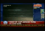
captain poe peel of the coast guard joining us live in north carolina. how is it looking? >> it is getting pretty good stiff breeze as you can imagine. she did is the thinking on how bad this is going to be? >> we are preparing for the worst as if it was going to be a direct hit. we've moved our resources to storm shelters trying to preposition to locations where we can get underway and come back out as soon as the storm moves out to conduct assessments and provide assistance. >> shepard: has it been your observance, thus far and those of others in the coast guard that small craft are staying in port and for the most part people are heeding the advice? >> yes. we saw one boat out at about 8:00 this morning. we did go to condition zulu which shuts down the ports in north carolina for traffic. we shutdown the ferry system a little after that. so far the boaters have heeded the warnings and stayed off,
12:15 am

which is great. the swimmers have stayed out of the water. i heard your last interview, they are right on, the riptides are going to be extremely dangerous the next couple of days. people along the beaches really need to be cale. >> shepard: people who get in with a riptide going they've never seen what riptides can did or they wouldn't do it. i was in westhampton dunes in the early part of the season two swimmers drowned out there, very good swimmers. they were trying to revive them on the beach. everybody was in shock, there was a riptide sometimes it will pull you out. >> no doubt about that. >> shepard: i guess the advice is until we hear more after the storm's past and the oceans stop churning just stay out of the water, right? >> they recommend 48 hours to let the currents calm down. you got a lot of water that falls and a lot of water surging back out offshore. it takes a while for those conditions to subside. >> shepard: if anybody can
12:16 am
handle this it is north carolina. you guys have certainly had the experience. good luck, we'll see you tomorrow. >> thank you, sir. >> shepard: thank you. next door in virginia the.ñh÷ united states navy tied down dozens of ships in norfolk. officials say earl is not dangerous enough so they have to move the ships from shore. the governor has declared a state of emergency and sent 200 national guard troops to the coast. steve harrigan is streaming live from virginia beach it appears to be a little windy. >> reporter: shepard, steady gusts now. it has been stronger than it was an hour ago. the trees now bending, but not breaking. the surf up as still more a sense of curiosity than fear. you have families walking, parents with children along boardwalk. people on the beach taking pictures. along these beach front hotels people taking pictures. more in expectation than fear. we did see people boarding up their windows with plastic or
12:17 am

wood not a sense of trepidation. right now experts saying the eye could pass more than 100 miles offshore. we could be looking here at 55 mile hour winds. the real concern seems to be what it could do for tourism this weekend. this is a major weekend here virginia beach there's a large concert series scheduled as well as a marathon, 20,000 expected to come into town the next 48 hours, travel might be delayed. right now that race is still scheduled to go on as planned. >> shepard: steve harrigan bringing updates from virginia beach as he will throughout the night and early morning, thank you. the greatest area of concern now outer banks of north carolina. eastern tip of long island, new york. and the coastal areas nantucket, martha's vineyard and the rest in massachusetts. those are the areas of greatest concern. here's another vary age, as the storm tracks up the -- variable, as the storm tracks up the east coast they wobble,
12:18 am

they don't go along a straight line they wobble from side-to-side. the closer it gets to the coast the more dangerous it is going to be. one interesting thing about in storm you hear with hurricanes the wettest and most dangerous is the lower right hand quadrant where all the rain usually is. this storm has a lot of rain on the left hand side or the westside of the storm. so there may be significant rain in the delmarva on long island in new york, up into connecticut, coast of maine and certainly in the coastal areas of massachusetts. we'll be covering all of that, including live on a ship off nova scotia in a moment as our coverage of hurricane earl continues. surf picking up in the carolinas, as is the wind. millions are watching this one to see if it is going to affect them directly. there's live coverage on fox news channel all night long, all morning long and all day tomorrow if you like hurricanes, you've come to the


12:22 am

. >> shepard: 21 minutes past 9:00 up and down the eastern seaboard. experts are warning folks from north carolina to massachusetts, do not let down your guard. one in particular saying hurricanes are completely unpredictable beasts. like our senior correspondent rick leventhal live on montauk in new york's long island way out on the eastern tip. lots of people on the beach not in the water, we are hoping ricky? >> reporter: certainly not tonight. not today either scepter surfers who love this weather. they wait for storm season. the waivers were kicking up, eight feet, 10 feet or more in some cases. the officials on long island are relieved. three million people live in nassau and suffolk counties there enough time to evacuate them all. if earl, the earl of hurricanes were to hit this
12:23 am

island, it would create significant problems for the island. instead, it seems to be jogging out further to the east and away from montauk, which is great news. again, they did close beaches today, closed them to swimming. we talked to beachgoers. we talked to a lifeguard who wasn't that impressed with earl so far, but was still keeping peep out of the water because of the danger. >> seen worse. >> reporter: you have? >> yeah, as far as the swell definitely seen it bigger and i've seen the ocean more rough. but as far as the storm getting this close and this big, i haven't seen it like that. >> reporter: so beaches closed today, definitely closed tomorrow to swimming. and the rain is supposed to start sometime tomorrow morning, probably bad by noon and throughout the day tomorrow. >> shepard: the earl of hurricanes. how are the officials getting ready? >> reporter: they have to get shelters ready, just in case.
12:24 am

we know there are 25 shelters in suffolk county and 25 more in nassau that standing by. they each have 1,000 cots and 1,000 blankets. they are not open yet that doesn't mean they won't open. even if the storm doesn't hit long island they might still open in case of power outages and flooding. here's what the red cross told us. >> if we don't open an evacuation shelter it dent moon we are out of the woods. we sit back, wait for the storm to pass. we are immediately doing disaster and damage assessments to find out if communites had been hard enough hit they are going to need ourselves for shelters afterwards. >> reporter: we heard from long island railroad. they are planning to shutdown a couple of lines heading out to montauk, because they are worried that power might be knocked out. trees might be knocked down to knock out crossing gates or block tracks. they are protectively closing
12:25 am

a couple of lines out here tomorrow. we know that long island power which handles the juice for the folks out here has more than 1600 out of state workers staging in an area a little further west. they have a couple hunt trucks, extra wires and transformers they you prepare odd to move in and restore how we are if it gets knocked out. >> shepard: ricky last stop? >> reporter: montauk. >> >> shepard: that's the long island railroad. rick leventhal at the end of the long island railroad, good luck. >> reporter: thanks. >> shepard: tom paul is braving it. he's a guy on ocracoke island in the carolinas, tom what are you doing? >> mostly listening to the storm of course it is dark and we can see anything. >> shepard: that's been one of my experiences over time as they come closer and closer winds get louder and louder then it starts to be a
12:26 am
whistling sound there's always a screen or something that cuts across the wind and makes a noise. you have heard that before, i'm guessing you are ready for it, right? >> yeah, we are ready for it, that's for sure. quite a few of us did not evacuate the island. we decided to wait it out. it appears as though the storm going to be as bad as we prepared for. >> shepard: that's the way you want it. better to overprepare than underprepare for sure. it is not fun to prepare. did you have to board up and all that sort of thing? >> yeah, we boarded up windows and picked up anything that might get blown around. the island looks tide before a hurricane than any other time it is a lot of work. in this case we really went overboard considering what was coming at us, looked like a category 4 now downgraded to a
12:27 am
category 2. so it seems like it is going to be a glancing blow. >> shepard: i sure hope you are right tom paul this afternoon a category 4. tonight category 2. prepare for the worst and mope for the best and maybe we'll get the best, unknown yet, tom thank you. every few hours official updates from the national hurricane center the group that flies the planes into the storm and tells us how fast the winds are blowing. we'll go live to the agency's director, with a deputy director, coming up. bottom of the hour means top of the news this is fox news of the news this is fox news channelel i don't see anything yet. no, over there, we've just gotta keep going to the left. what's your deal with going left? (rock music) get great deals during the bass pro shops labor day sale. your adventure starts here. got the gecko t-shirt... on is "4 million drivers switched!" gecko water bottle... notebook... chamois...
12:28 am

gecko: sir, i feel a little bit uncomfortable with all... you know... with all this. i mean, it's not about me. should be about how geico's the third-largest car insurance company in the nation. things like that. boss: oh, of course! we're not gonna get carried away. gecko: uh...yeah... all right as long as we don't overdo it. vo: geico. fifteen minutes could save you fifteen percent or more on car insurance.

12:30 am

weget doublemiles on every purchase. echo! so we eaed a trip to the grand canyon twice as fast. uh-oh. we get double mis every time we use r card. i'll te these. no matter what we're buying. plus the damages. and since double miles add up quick, we can bring thehole gang. it's hard to beat double miles. no we ride them! [ me announcer ] introducing the venture card from capital one, with le miles on evy purchase every day. go to capitalone.com. what's in your wallet? oh, that's the spot!
12:31 am
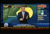
>> shepard: it is 9:30 on the east coast hurricane earl is making its i was up the shore. the next few hours could be the most interesting of the storm. it is moving past north carolina and virginia. the eastern end of those states getting some wind and rain now, about an hour and a half ago the national hurricane center downgraded earl to a category 2 from 115 miles-an-hour, which is a cat 3 to 110 miles-an-hour maximum sustained winds which is the strong end of a category 2. as you can see on the right, gusts clocked to a maximum of 140 miles an hour. that is nothing to sneeze at. deputy director of the national hurricane center ed rappaport joins us live from miami. good to see you, thank you.
12:32 am

>> good evening. >> shepard: tell us how this going to move or your best estimates tonight? >> the center of the hurricane is now located just to the south southeast of cape hatteras that is good news because it is moving on a track that is east of dew north. so it is going to move past the outer banks, staying offshore, at least the center will be offshore, by perhaps 50 miles or so, it is a large hurricane as we've been talking about. there are strong winds on the western side, most of the coastal area from north carolina up through the mid atlantic is going to be experiencing tropical storm force winds with the center offshore the hurricane force winds will be offshore too. down to only a 20% chance of hurricane force winds even at cape hatteras. as the storm moves northeast our next big risk is for southeastern new england. >> shepard: as you go in between, the delmarva, people who live in delaware, virginia, maryland, what might they be
12:33 am
able to expect or what should they be ready for in the overnight hours? >> most likely tropical storm force winds along the coast. i'll clear this out so you can see from the virginia border with north carolina all the way up to long island will have tropical storm force winds. at least gusts in further to the west sustained tropical storm force winds along the coast and approaching hurricane force winds again once you get out newnan tuckett, martha's vineyard area further out to the east. again, nearer to where the center of the hurricane is expected to pass. that will be tomorrow evening and overnight friday night to saturday. >> shepard: we talk about the cone of uncertainty a lot. there was a time when your models put together make it look as five there was a possibility that nantucket and other areas especially nova scotia and others it might pass directly over them.
12:34 am

is that still a possibility? >> let's look at that. we'll switch to another graphic. we can zero in. here's the east coast of the united states. we get up into nova scotia here this is the forecast track we are showing now. here's that cone you are talking about. the cone gives an idea of where the center of the hurricane could go, if it is off from our forecast track there. is still potential for the center to make it as far west as southeastern new england. the better scenario of course if it stays offshore as forecast, again the worst of the weather and highest of the storm surge generates could be off to the east. worst weather on the eastside. some risk for the center to pass near or perhaps a small chance passing over the nantucket area. most likely stay offshore, tropical storm force winds to near hurricane force winds in southern new england. >> shepard: you have been forecasting once that high pressure center began to dissipate and move east over
12:35 am

the atlantic this would take a turn and go up the shore sure enough man it looks like we can be hopeful that the worst of this is not going to hit us. >> that's the way it looks now, particularly for the north carolina area looks like the worst going to be offshore. if all goes well the worst of the weather will stay off of new england as well. >> shepard: ed rappaport in miami good to be with us, thank you for all you guys do. >> thank you. >> shepard: just in to fox news we'll move away from the hurricane to give new brand new video. this just in to fox news from the oil platform explosion in the gulf of mexico today. did you hear about this? another one happened off the coast of louisiana about 200 miles to the west of where that awful bp disas per -- disaster happened in this case 13 workers were on the platform at the time of the explosion. they all ended up in the water. they all made it back to shore.
12:36 am

12 life vests for 13 people. they all locked arms this is the new video after the flames had gone down the video they are showing is not of the tower in flames, but man it was earlier. no leaks of oil. initially were reports from the coast guard that there was an oil slick that stretched a mile that was not case. i don't know if we have the pictures when it was still up in flames or the workers in the water there. there were seven active wells from this platform they were shutdown before the fire started. all 13 people said to be back on dry land. nobody with any serious injuries. there were some injuries to one person, but nothing life-threatening. another explosion at an oil rig off the coast of louisiana today, no casualties. >> we are getting word the rain is starting to fall at kill devil hills in north carolina. we to -- we go to our
12:37 am

reporters. steve doocy sailing out in a bet in nova scotia, in canada eh! coming up with continuing special coverage of hurricane earl on fox news. m, did you borrow my green shirt? ♪ that's not really my style, honey. weird, i can't find it. ♪ [ female announcer ] new tide original with acti-lift technology
12:38 am

hey! you found it. yeah, it must have been hiding in my closet. [ female announcer ] new tide original with acti-lift. style is an option. clean is not. get acti-lift in these tide detergents.

12:40 am

>> shepard: 20 minutes before the hour and 20 minutes to on the record with greta van susteren. what is happening? >> greta: i just want to stick around for steve doocy in the sailboat. >> shepard: we are wondering if he is going to be all drunk out there. >> greta: that is enough reason for everybody to stay around. we are monitoring the hurricane. we got frank luntz about some of the campaign advertisements. also steve moore is here. disturbing news about the economy. that's a big surprise. any way, frankly, i don't want to miss steve doocy and shepard smith on a thursday night. >> shepard: it is going to be spectacular. maybe baby doocy will be there and have the whole doocy cla
12:41 am

this drinking it up like sailors. >> greta: hope peter is there. >> shepard: we call him baby doocy. can work -- can't believe you work this late,. >> greta: still another hour. >> shepard: millions of labor day weekends, major hurricane, bad come if you were planning to go somewhere on the east coast for labor day weekend, maybe miss tomorrow, saturday, sunday and monday, look out! any way bad pore businesses -- any way bad for businesses. steve centanni in ocean city, maryland looks like you got plenty of people there. nice shorts. >> reporter: go ahead shep. >> shepard: i was making finance of somebody, go ahead. >> reporter: they've come for the labor day weekend and none are going way there is no
12:42 am

evacuation order here. they are expecting earl to barrel up some distance off the coast parallel to ocean city, maryland. we'll stkpwoeplt of the side effects possibly tropical storm force winds more likely 30 to 40 miles-an-hour with gusts up to 55. they could cause damage. the winds will be high, the waves i'm sorry will be high. higher than the winds. surf has been big all day long. lifeguards have been warning people to stay out of water. if they go in just up to their knees and no further. they've been keeping an eye on that to keep people from getting hit by big waves flash flood the water comes up between midnight and noon tomorrow, they've gone along and fixed the sea wall, putting in these gates. let me show you one. this gap here, that's a gate that slides open or swings open. usually it is wide open. they've gone along, we had video from earlier, if we have that handy, you can roll it now.
12:43 am

they've gone up and down the beach for miles and miles and swung close these gates so if the water comes up over the sand up to the sea wall it won't come on to the bore wac where i'm standing. a lot -- the boardwalk where i'm standing. a lot of people are going to ride it pout in their hotels for about 12 hours. could be wind and rain we hope not any damage after that they are predicting good with weather. >> shepard: steve centanni, thank you. >> shepard: early in the mornings here on this channel they do this fox and friends thing. steve doocy has been on it since fluff was a kitten. he's sail on a boat off nova scotia, canada. joining us from the waters to the east of earl's path. steve, what is happening? >> reporter: good evening she did. you are right every one of those maps the red cone all leads to exactly where we are
12:44 am
right now. nova scotia. we got a nice day in nova scotia today. we were supposed to sail back toward new york. instead, what they've done, because earl is in the way, the captain is gonna drive -- right now we are heading out of halifax he's going to drive this thing to the east substantial layaway. >> shepard: where are you going london? >> no. he's going to head out toward bermuda and what he's hoping for is to be about 400 miles away from the center of the storm. so he essentially circumnav gates it. >> shepard: is baby doocy and momma doocy everybody? >> momma, sally, all here baby doocy got off the boat in halifax, he flew air canada to
12:45 am

boston and is en route to cape cod where he will be reporting on the storm tomorrow for fox news. she did 's steve son who works for us. what is his name again? >> that would be baby doocy. >> shepard: you don't remember his name, you are drunk again aren't you steve? >> not yet, it killing me, thursday night on the high seas, i could use a cocktail. i'm going to the rendezvous bar as soon as i'm done with the report. >> shepard: thursday is the new friday thank you for joining us in the middle of the deep blue sea to bermuda where fox producer jessica is, if you see her don't talk to her, be careful. earl has the potential to take out big chunks of business profits. the cost of hurricane earl, when special coverage of this storm continues. i'm shepard smith in new york. just 15 minutes to


12:49 am

she did lots of people headed down the >> shepard: lots of people head ed down the shore, will earl chase them from the beach? sean tobin live from sea isle city, new jersey. looks like the worst of earl can skip you. >> reporter: we would be all the better and happier for it here in sea isle city. a warm, moist summer night. it looks as though earl may spare the jersey coach the beach front real estate as well as plans for hundreds of thousands ready to come down and celebrate for the labor day weekend. as you can see behind me this is the scene low tide maybe half an hour to an hour. they think it may be three feet higher than normal. still, they are taking what they will get from earl's affects seriously. beach patrols up and down the coast taking precautionary
12:50 am

measures in ocean city, new jersey. bulldozers and back lows -- and backhoes cleared out drainage pipes, sea isle city a pitch south of atlantic city, they took their rescue boats off of the beach as well as the stands that were in the dunes. they knocked them down because they are worried about high winds overnight. right now precautionary measures along the lines that you see for a heavy nor'easter. >> shepard: it is my understanding were you a jersey shore lifeguard, i've guess you have seen worst than this? >> reporter: you know what they see this once or twice a year, it is all precautionary. they took all the trash cans back here. but, as far as the lifesaving effort, they remove the boogie boards those floatation devices that -- they kept people ankle,
12:51 am

knee deep. they are going to be feeling the affects tomorrow a little rain, a little wind. not a good beach day. >> shepard: got to watch for those riptides. good to see you. as we reported earlier the storm couldn't have come at a worse time for businesses that rely on labor day weekend tourism. adam shapiro with us. they need money this is the last hurrah. as if the yankees in the last round of the playoffs, you are making money. >> reporter: unless you are a mets' fan. cape hatteras, north carolina they are having their best tourist season since 2003 especially coming off last year you have 100% evacuation of the tourists they are gone. to put it into perspective, aa estimating the median amount a family is going to spend $697 that is not going to be spent
12:52 am

along the coast where this storm could possibly hit. most of it would have been spent on food and drinks and shopping itch it is gone. and it is not the kind of stuff you are going to get back. people aren't going back after the holiday >> shepard: it is not just the loss of business there's more. >> reporter: there is more. the last major storm that hit was isabel, over three billion dollars in damage. a couple of things are going to happen if the storm hits. you can't rebuild some of the houses. new zoning requires you to be further back from the water. a lot of people believe that it is this broken window scenario. if i break a window i'm creating some kind of economic benefit because the guy whose window i broke has to pay someone to fix it. the money that is going to repair that window could have gone to john the cabinet maker. now that money won't go there. the potential to grow is gone. you are going to be spending to get back where you were. that's the problem with these storms.
12:53 am

it can be a >> greta: killer. >> shepard: good to talk to with you all that great news. enjoy the weekend folks. more on earl is coming up. counting down to greta and watching the outer banks. hurricane earl has made the turn to north. many questions about massachusetts and certainably beach erosion along the way on long island, westhampton, westhampton dunes, where there is no jetty copd makes it hard for me to breathe. but with advair, i'm breathing better. so now, i can join the fun and games wi my grandchildren. great news! for people with copd, cluding chronic bronchitis, emphysema, or both, advair helps significantly improve lung function. while nothing can reverse copd, advair is different from most other copd medications because it contains both an anti-inflammatory and a long-acting bronchodilator, working together to help you breathe better. advair won't replace fast-acting inhalers for sudden symptoms and should not be used more than twice a day.
12:54 am

people with copd taking advair may have a higher chance of pneumonia. advair may increase your risk of osteoporosis and some eye problems. tell your doctor if you have a heart condition or high blood pressure before taking advair. i had fun today, grandpa. you and me both. if copd is still making it hard to breathe, ask your doctor if including advair will help improve your lung function for better breathing. get your first full prescription free and save on refills. like, keep one of these over your head. well, i wasn't "supposed" to need flood insurance, but i have it. fred over here chose not to have it. ♪ me, i've got a plan. fred he uh... fred what is your plan? do i look like i have a plan? not really. [ female announcer ] only flood insurance covers floods. for a free brochure, call the number on your screen.

12:56 am

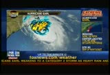
she did four minutes before 10:00 on the east coast. the latest on hurricane earl as it is making its way near the shore of the united states. earl was a strong category 4 this afternoon. as it moved it began the eye wall appeared to get -- the eye appeared to get smaller. the formation seemed to change some and the wind speed came down from 140 miles an hour at its maximum today earl is down to a category 2 storm maximum
12:57 am
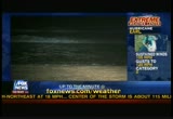
sustained winds 110 miles-an-hour gusts to 140 miles an hour. watch this loop when it restarts, right there now you will see it curve north. that's what the weather center here at fox had been predicting. it is very good news for the people of north carolina's outer banks. there was a concern not prediction, but concern that the storm wouldn't make the turn this early. instead would continue to head right for outer banks of north carolina and might give it a strong glancing blow. it now appears that worst-case scenario from this storm is not coming to fruition. instead, the storm is to skirt up the coast. what can you expect tonight in the outer banks and other areas of north carolina? tropical storm force winds for sure. close to hurricane force winds at the outer banks. live look at some of the waves from outer banks right now this is montauk, new york, which is perfect. we can talk about montauk.
12:58 am

this is the other end of the storm. by tomorrow afternoon it will be off the coast -- i said it is moving at 18 miles-an-hour. tomorrow afternoon it should be off long island, new york. there was concern the center might go over montauk east of long island still a possibility but not what the fox weather center is projecting nor the national hurricane center. the thinking is the storm goes east of the eastern tip of long island and then heads toward cape cod in massachusetts. there was a fear that the storm would go west of cape cod, meaning the worst of the storm would hit cape cod tomorrow. now the thinking is and the best projections national hurricane center, east of cape cod, make its way up toward nova scotia. what does that mean? outer banks, rain, wind, severe beach erosion would be the top. delmarva, delaware, virginia, maryland, coastal beach
12:59 am
erosion, coastal flooding, heavy rains for a period of time. winds up to tropical storm force but not for a long period of time. then the storm begins to go more quickly as it makes its way up the shore the jersey shore along new york's long island and connecticut and areas north. the same sort of situation, the storm is moving quickly. rather than tropical storm force winds and rain for four or five hours the time may be less as the storm speeds up. in addition, the water is much colder once you get to the north. it is as warm as it has been in many years much colder than it is now. that takes some of the energy out. by the time it gets to cape cod and other areas of massachusetts off the coast of maine even to nova scotia the storm may pack much less of a punch and could be very well a category 1 by then. no matter what happens the fox news teams are up and live for you all night. the fox weather center will not sleep. our correspondents will be stationed up and down. as the storm begins to
201 Views
IN COLLECTIONS
Fox News Television Archive
  Television Archive News Search Service
  The Chin Grimes TV News Archive
Uploaded by TV Archive on
